
படிமம்:Cyprus districts named.png
இதைவிட அளவில் பெரிய படிமம் இல்லை.
Cyprus_districts_named.png (600 × 365 படவணுக்கள், கோப்பின் அளவு: 22 KB, MIME வகை: image/png)

|
This map image could be re-created using vector graphics as an SVG file. This has several advantages; see Commons:Media for cleanup for more information. If an SVG form of this image is available, please upload it and afterwards replace this template with
{{vector version available|new image name}}.
It is recommended to name the SVG file “Cyprus districts named.svg”—then the template Vector version available (or Vva) does not need the new image name parameter. |
சுருக்கம்
| விளக்கம் |
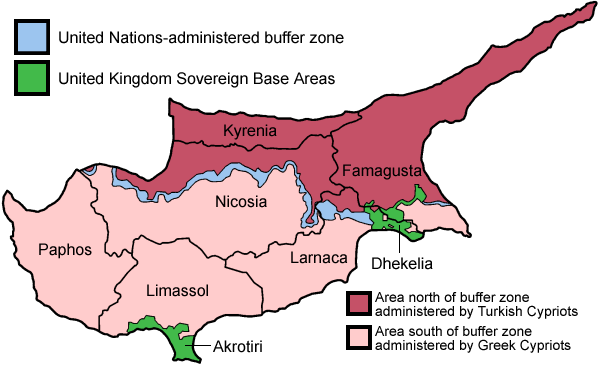
English: Map of the districts of Cyprus, named in English, with English annotations, and showing the Turkish Republic of Northern Cyprus, United Kingdom Sovereign Base Areas, and United Nations buffer zone. The individual maps see below.
Deutsch: Karte der Distrikte Zyperns: Bezirke der Republik Zypern, Türkische Republik Nordzypern, UK-Militärbasen, UN-Pufferzone (englische Beschriftung). Zu den Einzelkarten siehe unten "Individual maps". |
| நாள் | |
| மூலம் | சொந்த முயற்சி (traced from public domain UN or CIA maps.) |
| ஆசிரியர் | Golbez |
| ஒத்தக்கோப்பு |
Français : File:Carte des districts de Chypre.png
Ελληνικά: File:Cyprus districts named el.png
|
அனுமதி
இந்த ஆக்கத்தின் காப்புரிமையாளரான நான் இதனைப் பின்வரும் உரிமத்தின் கீழ் வெளியிடுகின்றேன்:
This file is licensed under the Creative Commons Attribution-Share Alike 2.5 Generic, 2.0 Generic and 1.0 Generic license.
- நீங்கள் சுதந்திரமாக:
- பகிர்ந்து கொள்ள – வேலையை நகலெடுக்க, விநியோகிக்க மற்றும் அனுப்ப
- மீண்டும் கலக்க – வேலைக்கு பழகிக்கொள்ள.
- கீழ்க்காணும் விதிகளுக்கு ஏற்ப,
- பண்புக்கூறுகள் – நீங்கள் பொருத்தமான உரிமையை வழங்க வேண்டும், உரிமத்திற்கான இணைப்பை வழங்க வேண்டும் மற்றும் மாற்றங்கள் செய்யப்பட்டிருந்தால் குறிப்பிட வேண்டும். நீங்கள் ஏற்புடைய எந்த முறையிலும் அவ்வாறு செய்யலாம், ஆனால் எந்த வகையிலும் உரிமதாரர் உங்களை அல்லது உங்கள் பயன்பாட்டிற்கு ஒப்புதல் அளிக்கும் படி பரிந்துரைக்க கூடாது.
- அதே மாதிரி பகிர் – நீங்கள் ரீமிக்ஸ் செய்தாலோ, உருமாற்றம் செய்தாலோ அல்லது பொருளை உருவாக்கினாலோ, உங்கள் பங்களிப்புகளை அல்லது இணக்கமான உரிமம் கீழ் அசலாக விநியோகிக்க வேண்டும்.

|
GNU Free Documentation License விதிமுறைகளின் கீழ் இந்த ஆவணத்தை நகலெடுக்க, விநியோகிக்க மற்றும்/அல்லது மாற்றுவதற்கு அனுமதி வழங்கப்பட்டுள்ளது, Free Software Foundation;ஆல் வெளியிடப்பட்ட பதிப்பு 1.2 அல்லது அதற்குப் பிந்தைய பதிப்பு, மாற்றமில்லாத பிரிவுகள், முன் அட்டை உரைகள் மற்றும் பின் அட்டை உரைகள் இல்லாமல் வெளியிடப்பட்டது. GNU Free Documentation License என்ற தலைப்பில் உரிமத்தின் நகல் சேர்க்கப்பட்டுள்ளது. |
| இந்த கோப்பு Creative Commons Attribution-Share Alike 3.0 Unported உரிமத்தின் கீழ் உள்ளது. | ||
| ||
| This licensing tag was added to this file as part of the GFDL licensing update. |
நீர் உமக்கு விருப்பமான உரிமத்தை தேர்ந்தெடுக்கலாம்.
Individual maps of the Cyprus districts
கோப்பின் வரலாறு
குறித்த நேரத்தில் இருந்த படிமத்தைப் பார்க்க அந்நேரத்தின் மீது சொடுக்கவும்.
| நாள்/நேரம் | நகம் அளவு சிறுபடம் | அளவுகள் | பயனர் | கருத்து | |
|---|---|---|---|---|---|
| தற்போதைய | 20:38, 30 மே 2010 | | 600 × 365 (22 KB) | Wknight94 | Reverted to version as of 14:28, 13 August 2007 ---- latest upload with no new info on source, etc. |
| 23:46, 17 நவம்பர் 2008 |  | 700 × 482 (94 KB) | Guntars strazdins | {{Information |Description= |Source= |Date= |Author= |Permission= |other_versions= }} | |
| 23:44, 17 நவம்பர் 2008 |  | 700 × 482 (94 KB) | Guntars strazdins | {{Information |Description= |Source= |Date= |Author= |Permission= |other_versions= }} | |
| 14:28, 13 ஆகத்து 2007 |  | 600 × 365 (22 KB) | Lexicon | Reverted to earlier revision | |
| 14:28, 13 ஆகத்து 2007 |  | 600 × 365 (54 KB) | Lexicon | buffer zone and SBA colours flipped, since buffer zone is called the "Green Line" | |
| 06:07, 30 சூன் 2005 |  | 600 × 365 (22 KB) | Golbez | Got Dhekelia wrong again. Final version unless others have comments. | |
| 02:04, 28 சூன் 2005 |  | 600 × 365 (22 KB) | Golbez | Updated again, final version for now, cleaned up text and the Dhekelia area. | |
| 17:51, 27 சூன் 2005 |  | 600 × 365 (20 KB) | Golbez | Fixed a color | |
| 17:44, 27 சூன் 2005 |  | 600 × 365 (20 KB) | Golbez | Updated map with different color for north and south, and enclaves in Dhekelia. | |
| 09:48, 27 சூன் 2005 |  | 600 × 365 (19 KB) | Golbez | Map of the districts of Cyprus Source: Made by User:Golbez. {{cc-by-sa-2.0}} Category:Maps of Cyprus\ |
கோப்பு பயன்பாடு
பின்வரும் பக்க இணைப்புகள் இப் படிமத்துக்கு இணைக்கபட்டுள்ளது(ளன):
கோப்பின் முழுமையான பயன்பாடு
கீழ்கண்ட மற்ற விக்கிகள் இந்த கோப்பை பயன்படுத்துகின்றன:
- af.wikipedia.org-திட்டத்தில் இதன் பயன்பாடு
- ar.wikipedia.org-திட்டத்தில் இதன் பயன்பாடு
- arz.wikipedia.org-திட்டத்தில் இதன் பயன்பாடு
- az.wikipedia.org-திட்டத்தில் இதன் பயன்பாடு
- az.wiktionary.org-திட்டத்தில் இதன் பயன்பாடு
- be.wikipedia.org-திட்டத்தில் இதன் பயன்பாடு
- bs.wikipedia.org-திட்டத்தில் இதன் பயன்பாடு
- ca.wikipedia.org-திட்டத்தில் இதன் பயன்பாடு
- Conflicte de Xipre
- Resolució 187 del Consell de Seguretat de les Nacions Unides
- Resolució 192 del Consell de Seguretat de les Nacions Unides
- Resolució 193 del Consell de Seguretat de les Nacions Unides
- Resolució 194 del Consell de Seguretat de les Nacions Unides
- Resolució 198 del Consell de Seguretat de les Nacions Unides
- Resolució 201 del Consell de Seguretat de les Nacions Unides
- Resolució 206 del Consell de Seguretat de les Nacions Unides
- Resolució 207 del Consell de Seguretat de les Nacions Unides
- Resolució 219 del Consell de Seguretat de les Nacions Unides
- Resolució 220 del Consell de Seguretat de les Nacions Unides
- Resolució 222 del Consell de Seguretat de les Nacions Unides
- Resolució 231 del Consell de Seguretat de les Nacions Unides
- Resolució 244 del Consell de Seguretat de les Nacions Unides
- Resolució 254 del Consell de Seguretat de les Nacions Unides
- Resolució 266 del Consell de Seguretat de les Nacions Unides
- Resolució 274 del Consell de Seguretat de les Nacions Unides
- Força de les Nacions Unides pel Manteniment de la Pau a Xipre
- Resolució 293 del Consell de Seguretat de les Nacions Unides
- Resolució 305 del Consell de Seguretat de les Nacions Unides
- Resolució 315 del Consell de Seguretat de les Nacions Unides
- Resolució 324 del Consell de Seguretat de les Nacions Unides
- Resolució 334 del Consell de Seguretat de les Nacions Unides
- Resolució 343 del Consell de Seguretat de les Nacions Unides
- Resolució 349 del Consell de Seguretat de les Nacions Unides
- Resolució 358 del Consell de Seguretat de les Nacions Unides
- Resolució 360 del Consell de Seguretat de les Nacions Unides
- Resolució 361 del Consell de Seguretat de les Nacions Unides
- Resolució 364 del Consell de Seguretat de les Nacions Unides
- Resolució 365 del Consell de Seguretat de les Nacions Unides
- Línia Verda (Xipre)
- Resolució 593 del Consell de Seguretat de les Nacions Unides
- Resolució 716 del Consell de Seguretat de les Nacions Unides
- Resolució 774 del Consell de Seguretat de les Nacions Unides
- Resolució 969 del Consell de Seguretat de les Nacions Unides
- Resolució 1475 del Consell de Seguretat de les Nacions Unides
- Resolució 1517 del Consell de Seguretat de les Nacions Unides
- ckb.wikipedia.org-திட்டத்தில் இதன் பயன்பாடு
சிறப்பு பக்கம்-மொத்த பயன்பாடு - இதன் மூலம் இந்த கோப்பின் மொத்த பயன்பாட்டை அறிய முடியும்